
BergeSeen Trail Stage 18
From the Albert Appelhaus to the Rinnerhütte
The trail descends through a sparsely forested and rocky terrain to the meadows of the Wildenseealm (1525 m) with its many small alpine huts. The Wildenseehütte is a self-catering hut at this location. The route continues along flat terrain to the northwest arriving at the Hufnagelwiese meadow and then immediately thereafter the gorgeous Lake Wildensee (1535 m).
After a short ascent over a corrie threshold, the trail continues through a flat alpine valley alongside a stream which disappears at times into the rock. Two different paths lead off to the left to the 2012 meter high Rinnerkogel peak. The trail continues to the small Rinnerhütte (1474 m), an alpine hut belonging to the Ebensee Mountaineering Association which offers food and drink.
From the Rinnerhütte to Lake Offensee
The trail leads out of the valley along relatively flat terrain past a spring to the edge of the plateau, from which Lake Offensee can be seen far below. The route then enters steep mountainous terrain, and the descent winds along several curves to the Rinnerboden, where a spring provides fresh drinking water. The trail continues to a waterfall and then onward down a steep descent.
An especially steep section of the trail is covered by means of a metal staircase until finally reaching the valley floor and a forest road. The route continues to the right along this road for 1.6 kilometres to arrive at the shore of Lake Offensee. Heading left along the lakeshore, the hikers can quickly reach the snack station Seeau.
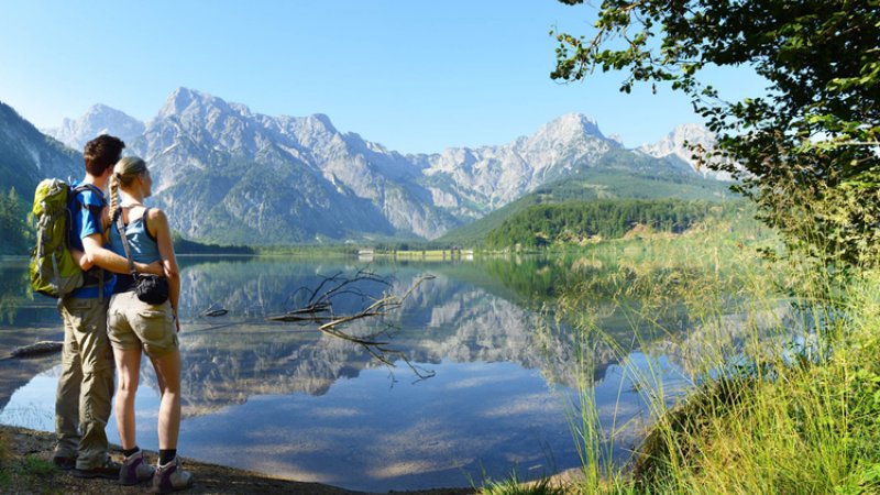
From Lake Offensee to Lake Almsee
A few metres prior to reaching Lake Offensee, a broad path leads off to the right in the direction of Lake Almsee (path no. 420). The narrow ascent heads upward through the forest to the Gschirrsattel (saddle at 1029 m). Four hundred metres of elevation are covered during this climb. From the saddle (marker), the trail continues along flat terrain to a forest road.
The trail continues left downhill along this road passing above the Gschirrhütte (hunting lodge) to arrive at the Weißenegg hunting lodge. In front of the lodge, the trail heads right over the bridge and continues downhill for 2.5 kilometres along the forest road to an intersection. The route goes along the road to the right for a short distance and then descends left along a footpath down a 50 meter slope to the Nesseltal Stream. On the other side of the valley, the trail ascends again to another forest road which it follows for 2.5 kilometres until reaching a footpath on the right. This path leads to Deutsches Haus which is located on the shore of Lake Almsee.
The trail continues along the street to arrive in a short time at the Gasthof Seehaus tavern. From there, a splendid hiking trail begins along the eastern lakeshore to a small charming cove with particularly stunning views of the mountains to the south of the lake.
From Lake Almsee to Gasthof Jagersimmerl
Heading along the path, the trail continues to wind around Lake Almsee which narrows along the way. After reaching the end of the lake, it’s only a short distance to the well-known Gasthof Jagersimmerl inn, the final destination of this very long stage.
Many prominent figures have explored this region: nobles like Archduke Johann and Empress Elisabeth, scientists such as Friedrich Simony, poets and authors like Nikolaus Lenau, painters like Ferdinand Georg Waldmüller, musicians and composers such as Johannes Brahms. Did they ever think that hiking in the Salzkammergut might have no end? That they could tramp from one lake to the next and then onward to yet another? Day by day along the shores of crystal-clear waters? Week-long excursions through quiet valley forests, over sunny alpine meadows and up mountains fuelled by the anticipation of the next destination? Further information… The days in the Salzkammergut are getting longer. The temperatures are finally getting warmer, more and more hikers are heading to the mountains. But be careful: Especially in spring, there are a few things to consider: There is often still a lot of snow on the mountains, so be careful when crossing snowfields. After winter, you are usually still a bit "rusty", so warm up accordingly in advance and plan your tour carefully. Let your host know the planned route. This can lead to quick help in an emergency. But there's more to consider: The days in the Salzkammergut are getting longer. The temperatures are finally getting warmer, more and more hikers are heading to the mountains. But be careful: Especially in spring, there are a few things to consider: There is often still a lot of snow on the mountains, so be careful when crossing snowfields. After winter, you are usually still a bit "rusty", so warm up accordingly in advance and plan your tour carefully. Let your host know the planned route. This can lead to quick help in an emergency. But there's more to consider: Admittedly, the landscape of the UNESCO World Heritage region of Hallstatt Dachstein Salzkammergut is the absolute pinnacle for hiking fans, mountain enthusiasts and nature lovers—unforgettable tours to incredibly beautiful mountain lodges and meadows, panorama views as far as the eye can see and cherished moments that will last a lifetime! However, you should remember that while hiking you might find yourself in high-alpine terrain. We’ve put together some resources to assist you: how to best prepare for your tour, recommended items for your backpack and steps to take in an emergency situation. Remember to always play it safe and enjoy your hiking adventure in the Salzkammergut! Hiking trails in the Salzkammergut can be closed for various reasons. To help you prepare for your hike, we have set up a page with current road closures in the region. This will help you get to your destination without any detours or stress. Click here to visit the page...Tips: Hiking in spring
Tips: Hiking in spring
Safety Tips for Hikers
Warning: Closed trails
Better to know before you go